
Home Blog Page 38

Meerut Metro: A fast-moving dream changing the city’s direction 

Introduction

Meerut has always been a city with a strong past. Walk through it, and you will find reminders everywhere. Old markets, colonial era buildings and landmarks like the Augarnath Temple are closely linked to the uprising of 1857. The city played a crucial role in the Indian Rebellion of 1857, and that legacy still shapes its identity. But while history gave Meerut recognition, it did not guarantee growth. 

Over the years, the city expanded rapidly. By 2026, the city’s population will stand at around 1,964,000, while the larger urban region population is around 2,139,000. In 2026, Meerut ranked as the 34th most populous city in India. It also became the second-largest city in the National Capital Region, right after Delhi. This kind of growth brings opportunity.

Now, Meerut has grown in size and ambition. New residential areas came up, population increased, and business activity grew, especially in sectors like sports goods, metal work and agricultural-based trade. At the same time, Meerut remained closely tied to Delhi. Thousands of people travelled daily between the two cities for work, education and business. And that’s where the problem began. The city’s infrastructure struggled to keep up. Roads became overcrowded, public transport remained limited, and long travel hours became part of daily life. Within the city, moving from one area to another often meant dealing with traffic congestion and delays. The growing gap between expansion and infrastructure created a clear need. Meerut needed a faster, more reliable, and structured transport system. At the same time, planners saw an opportunity. With its strategic location near  the National Capital Region, Meerut could become more than just a neighbouring city. It could become an active economic extension of Delhi. But for that connectivity had to improve. This idea gave rise to the Meerut Metro, integrated with the Namo Bharat Corridor. 

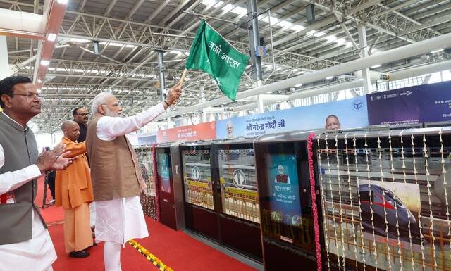
On 26 February 2026, when Prime Minister Narendra Modi inaugurated the project, it marked a turning point. The city that once depended on slow, crowded roads suddenly gained access to high-speed modern transit. 

This article explores the journey of the Meerut Metro in detail. It explains the metro’s current network and future expansion plans. It also studies its impact on business and the city. It also examines financial and operational challenges. Because the real question is simple. Can this metro truly change Meerut’s future? 

Meerut Metro: The journey from plan to reality
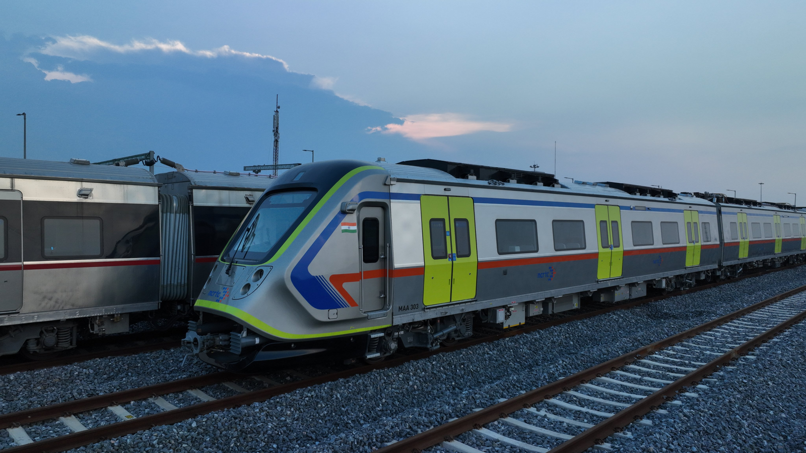
image 7

The Meerut Metro did not appear overnight. It took years of planning, studies, and coordination before the first train could run. The idea started in the early 2010s. At that time both the center government and Uttar Pradesh government began to look at better transport options for cities near Delhi. Meerut stood out because of its growing population and strong daily connection with the capital. Officials wanted a system that could solve two problems at once. They wanted to improve travel within the city. They also wanted faster connectivity with Delhi and outer NCR areas. This thinking led to a combined vision. The Meerut Metro would work along with the Namo Bharat corridor instead of running as a completely separate project. The next step involves technical studies.

In 2015, RITES did a feasibility study. The study examined whether the metro would work in Meerut. It looked at expected passenger demand, costs, routes, and long-term benefits. After that in June 2016, the agency prepared the Detailed Project Report (DPR). The DPR acted as the blueprint for the project. It defined the route, station locations, cost estimates, and construction plan. Once the DPR was ready, the project moved into the approval stage. 

In 2017, the Uttar Pradesh Metro Rail Corporation took on a key role. It worked as a coordinator between different agencies. Large infrastructure projects require multiple stakeholders, including  state authorities, central ministries, and technical teams. UPMRC helped bring them together. 

A major milestone came on 8 March 2019. On this day Prime Minister Narendra Modi laid the foundation stone for both the Meerut Metro and the regional rapid rail project. This marked the official start of the construction. Work began soon after in July 2019. Construction did not move easily. Like most large projects, it also faced challenges. Teams had to deal with land acquisition, traffic management, and complex engineering work. Building Underground stations in busy areas like Begumpul and Meerut Central required careful planning and execution. At the same time engineers worked on integrating the metro with the Namo Bharat system. This step made the project unique. Instead of building separate tracks, both systems would share the same infrastructure in the Meerut section. 

Over the next few years, the project moved steadily forward. Trial runs began in early 2025. Finally on 22 February 2026, the Prime Minister flagged off the Metro for the public. 

Quick overview: Meerut Metro at a glance

Details Information
Inauguration 22 February 2026
Total corridor23.60 km
Stations (city network)13
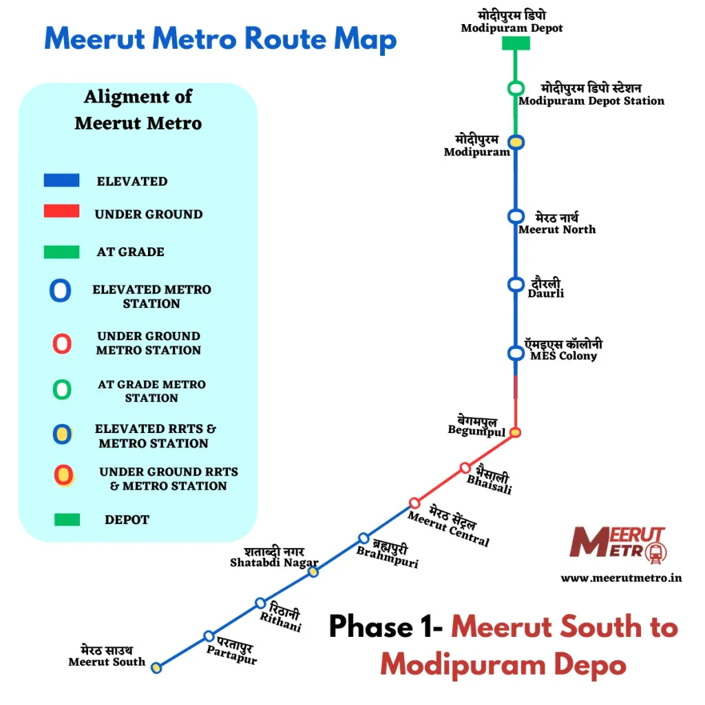
Key stationsMeerut South, Pratapur, Rithani, Shatabdi Nagar, Brahmapuri, Meerut Central, Bhaisali, Begumpul, MES Colony, Daurli, Meerut North, Modipuram, Modipuram Depot
SpeedUp to 120 kmph 

Existing routes

image 5

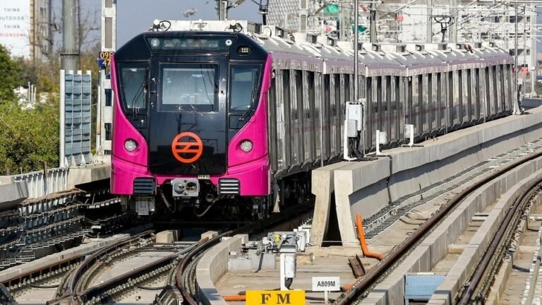
The current Meerut Metro Corridor runs from Meerut South to Modipuram. It covers around 23 km and connects important parts of the city. This route includes both elevated and underground sections. The elevated track covers about 16 km, while the underground tunnels stretch for around 7 km through dense urban areas. The system includes 13 stations in total.

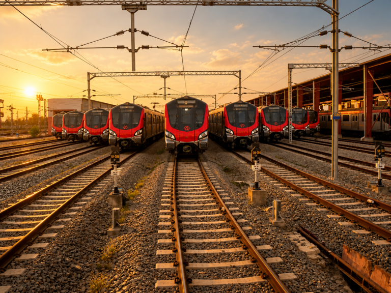
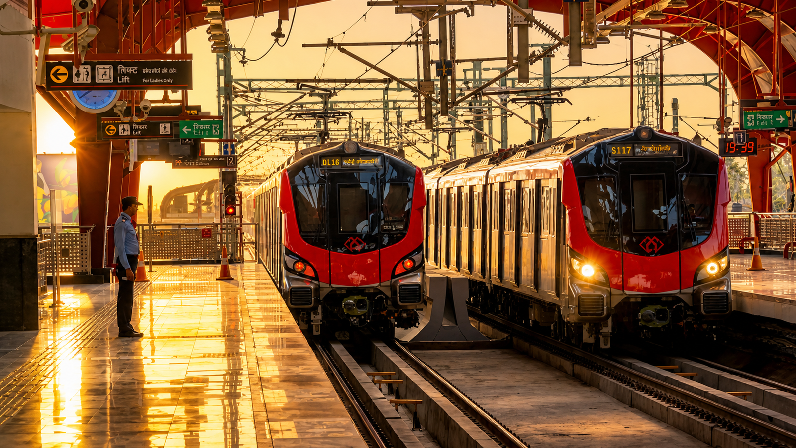
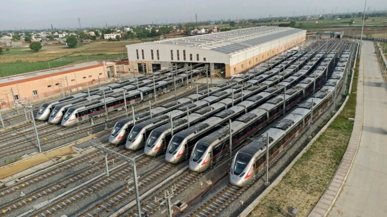
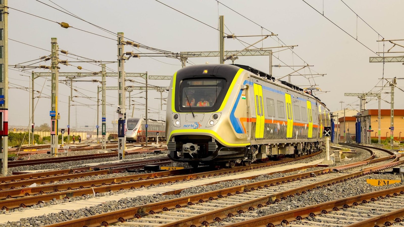
One of the most important features of the Meerut Metro is its integration with the Namo Bharat. The metro shares tracks and infrastructure with the semi high-speed regional rail. The setup allows passengers to move between local and intercity travel without switching stations. A commuter can travel within Meerut and continue towards Delhi using the same network. Meerut Metro also stands out for its speed. With an operational speed of up to 120 kmph, it is currently considered India’s fastest metro system. It can cover the city corridor in about 30 minutes. During the peak hours, trains arrive every 5 to 10 minutes, which supports daily commuting. 
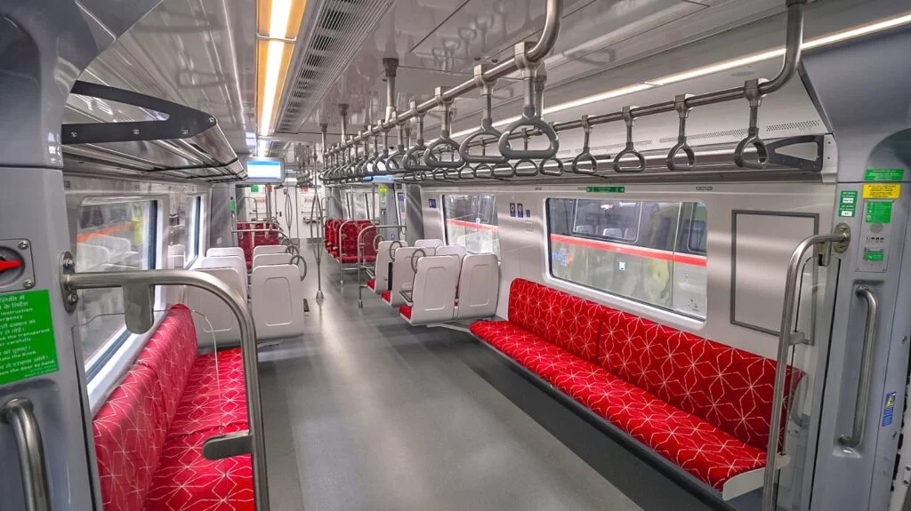
image 6

Future expansions

The current Meerut Metro provides a strong base, but it does not cover the entire city. Authorities have proposed additional corridors to improve network reach and maybe a more effective system. One of the key proposals is Line-2, which will connect Shradhapuri Phase 2 to Jagriti Vihar. This corridor aims to link several dense residential and commercial areas, improving accessibility across important parts of the city. 

Proposed Line 2: Shradhapuri Phase 2 to Jagriti Vihar

DetailsInformation
Length15 km
Type10.7 km elevated and 4.3 km underground
Number of stations13
statusproposed
Proposed stationsShradhapruri Phase 2, Kanker Khera, Meerut cantt, Railway station, Rajban Nagar, Begumpul, Baccha Park, Shahpeer gate, Hapur Adda Chauraha, Gandhi Ashram, Mangal Pandey Nagar, Taj Grahi, Medical College, Jagruti Extension
Implementing agencyUttar Pradesh Metro Rail Corporation (UPMRL)

Line 2 is expected to strengthen connectivity within Meerut by linking areas that currently depend heavily on road transport. It will also improve access to major transit points like Meerut Cantt, Railway Station, making multimodal travel more convenient. In addition, this corridor can support future urban expansion. It can guide planned growth and reduce unstructured development by connecting developing areas such as Mangal Pandey Nagar and Jagriti Vihar

If implemented effectively, Line 2 will not only increase the metro’s coverage but also improve its usability for a larger section of the population. It can play a key role in boosting ridership and making the metro a more practical option for daily commuting. 

Business and economic impact

The Meerut Metro influences the economy beyond transportation. It supports urban development, business growth, and environmental improvement. 

Real Estate and urban developement 

Metro connectivity often increases the value of nearby properties. Meerut has started to experience this trend. Areas around metro stations have become more attractive for residential and  commercial development. Locations such as  Begumpul, Modipuram, and Shatabdi Nagar are witnessing increased demand. Property values near metro stations have risen from Rs 8,000 to 12,000 per square yard to Rs 12,000 to 20,000 per square yard over time. Improved connectivity encourages people to invest in these areas. 

Transit Oriented Development (TOD) will further support this growth. Planned development around stations, can lead to organised urban expansion. This approach can reduce unplanned growth and improve infrastructure planning. 

Employment and commercial activity

The metro project has created employment at multiple levels. Construction work generated direct jobs. Operations and maintenance continue to support employment. Beyond the project itself, the metro creates opportunities for businesses. 

Commercial activity is expected to grow around metro stations. Offices, retails spaces, and small business centers are likely to come up near these locations. These areas will offer easy access for daily commuters. It will make them attractive for companies and employees. As a result, station zones may develop into active business hubs. This can also create new job opportunities and support local economic activity around the metro network.

Environmental sustainability 

The Meerut Metro is also playing an important role in improving the city’s environmental conditions. Urban trans[ortation remains one of the main contributors to pollution in cities like Meerut. Increasing use of private vehicles has led to higher emissions, traffic congestion, and declining air quality. In this context, the metro offers a cleaner and more efficient alternative. Electric trains produce significantly lower emissions compared to petrol and diesel vehicles. As more people shift to rail based transport, the overall pressure on roads can reduce. This shift is expected to take nearly 1 lakh private vehicles off the roads over time. As a result, It could see a reduction of around 2.5 lakh tonnes of carbon emissions annually. The impact goes beyond numbers. Fewer vehicles on the road means less congestion, smoother traffic flow, and better urban air quality. At a broader level, projects like the Meerut Metro reflect a shift in how cities approach development. They show a growing focus on cleaner mobility and planned urban growth. 
image

Challenges: A Closer Look at Ground Reality

Despite its advantages, the Meerut Metro faces several challenges. These challenges may affect its long term performances. 

Ridership and revenue gap

A metro system depends on regular passenger use. Meerut currently lacks the high commuter density seen in larger metro cities. Many people prefer cheaper and flexible transport options such as auto-rishkaws and buses. These options provide door-to-door connectivity. If ridership remains low, revenue from ticket sales will not meet operational costs. This gap can affect financial stability. 

Financial Stability

Metro projects required large investment. Costs include construction, maintenance and daily operations. If revenue remains limited, the system may remain on government support. This can create financial pressure over time. Long-term sustainability requires:

  • Increasing ridership
  • Expanding commercial revenue 
  • Efficient cost management 

Infrastructure projects often deliver benefits over a long period, but financial challenges appear early. 

Competition and limited resources

Meerut already has an established informal transport system. Autos and shared vehicles provide flexible travel options. The metro cannot replace these services completely. Instead, it must work alongside them. Limited network coverage also affects usage. If the metro does not connect key areas like Ganga Nagar, Shastri Nagar, Pallavpuram and peripheral zones like Ved Vyas Puri, commuters may choose other options. 

Strong last-mile connectivity is essential. Feeder services must support the metro network to improve accessibility.  

Conclusion

The Meerut Metro has given the city a new direction. For a place that relied heavily on roads, this shift matters. Daily travel no longer depends only on traffic conditions and long delays. For many people, the metro has already started to make movement easier and more predictable. With its link to the Namo Bharat, the distance between Meerut and Delhi feels shorter in Practical terms. The changes are gradual but noticeable. Areas around stations are becoming more active. Small shops, service providers, and local businesses are seeing more Movement. At the same time, the system is still in its early stages. Its long-term success will depend on how people respond to it. Convenience will play a major role. If reaching the station is easy and the service remains reliable, more people will choose the metro over other options. 

There are also practical concerns. The network is still limited in coverage. Many areas remain outside its reach. Local transport, such as auto and e-rickshaws, will need to support the system better. Without strong last-mile connectivity, the metro can not serve its full purpose. Financial stability is another factor. Running a metro system requires steady usage. If passenger numbers remain low, it will take longer to recover costs. That is why expansion and consistent ridership will matter in the coming year. Even with these challenges, the metro has created a strong base. It has introduced a faster way to travel and opened up new possibilities for growth. It has also shown how better infrastructure can change the pace of a city. Meerut now has an opportunity. If the system grows in the right direction and people begin to rely on it, the metro can become a central part of daily life.

Also Read: Mumbai-Ahmedabad Bullet Train Project completes all 13 Portal Beam launches
Mumbai-Ahmedabad Bullet Train Project completes all 13 Portal Beam launches
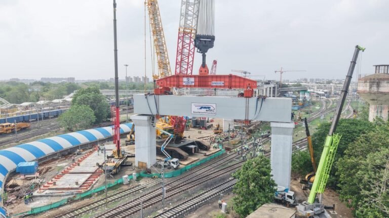
AHMEDABAD (Metro Rail News): The Mumbai-Ahmedabad Bullet Train Project has reached a significant construction milestone with the successful installation of all 13 heavy portal beams in Ahmedabad. The last and heaviest beam was placed at Sabarmati, finishing a crucial part of the viaduct construction over existing railway lines.

According to the NHSRCL Press Release, The project team completed the launch of the final portal beam on Friday. This beam weighs about 1,640 metric tonnes, making it the heaviest precast concrete portal beam among all 13 installed in Ahmedabad.  The 18-km-long bullet train viaduct in Ahmedabad crosses some of the city’s busiest railway routes at an elevated level. Engineers designed and installed these portal beams to safely support the high-speed rail viaduct over the existing railway tracks.  

13 portals beams installed at key locations 

NHSRCL has launched a total of 13 heavy portal beams at different sites in Ahmedabad:

  • Five portal beams over the Mumbai, Ahmedabad main railway line at Maninagar  
  • Seven portal beams over the Mumbai, Ahmedabad main railway line at Vatva  
  • One portal beam over the Ahmedabad, Delhi main railway line at Sabarmati

After the installation of this beam at Sabarmati, all planned heavy portal beam launches in Ahmedabad are now complete. 

Heaviest beam installed in 3 hours  

The final portal beam measures 34.5 metres in length and has a cross-section of 5.5 metres × 4.5 metres. It is one of the largest precast portal beams used in the project. The construction team completed the entire launching operation in around three hours. To lift and place the beam, engineers used a 2,200-metric-tonne crawler crane. They carried out the operation in a restricted work area while following strict safety measures. The team also worked closely with Indian Railways to ensure train services continued safely during the lifting process.  

Portal Beam Dimensions at a glance 

Ahmedabad Section
Sr no.Portal BeamDimension (m)Weight (MT)
1497-P0534 x 5.5 x 4.51352
2497-P0633 x 5.5 x 4.51360
3497-P0730 x 5.5 x 4.51329
4497-P0830 x 5.5 x 4.51342
5497-P0930 x 5.5 x 4.51322
Vatva Section
1489-P1417 x 5.5 x 3.2555
2489-P1517 x 5.5 x 3.2564
3489-P1617 x 5.5 x 3.2558
4490-P1117 x 5.5 x 3.2557
5490-P1217 x 5.5 x 3.2564
6490-P1317 x 5.5 x 3.2571
7490-P1418.15 x 5.5 x 3.2574
Sabarmati Section
1506P634.5 x 5.5 x 4.51640

Also Read: High-Speed Rail: NHSRCL invites bids to design civil structures for future 350 kmph bullet train corridors

Nagpur Metro gears up for 55km expansion: RITES awarded DPR contract

NAGPUR (Metro Rail News): Nagpur Metro is all set to expand its branches across the city with four new proposed Phase-3 corridors. Rail India Technical and Economic Service (RITES) has been awarded the contract of Rs. 3.12 crore to prepare a Detailed Project Report (DPR) and Alternate Analysis Report (AAR) for the proposed 55 km metro alignment. The ground work of this project is expected to begin in the coming two weeks. 

The four Proposed Corridors are: 

CorridorsLength
Mankapur Chowk–Rachana Junction (Inner Ring Road)25 km
Sitabuldi–Koradi11.5 km
MIDC ESR–CEAT Ltd (Butibori Extension)3 km
Khapri–New Nagpur15 km

The completion period for the DPR is 270 days. RITES will also conduct feasibility studies for the introduction of the first driverless trains for the Phase-3 of Nagpur metro, and also confirm if an underground corridor can be constructed for the Phase-3. These four new corridors connect major industrial areas, growing residential ones and the proposed New Nagpur township along with circular connectivity through Ring Road. Officials said the DPR will act as a roadmap for the largest expansion of the Nagpur Metro to date. The addition of 55 km to the existing Phase 1 and 2 would expand Nagpur metro’s network to 139 km.

The Sitabuldi–Koradi corridor is a key focus area, as existing flyovers, dense urban development, and limited availability of land could make an elevated construction difficult. The final route, technology, and construction method will be decided after detailed engineering and feasibility assessments.

RITES will perform traffic and ridership surveys, peak hour peak direction traffic surveys, peak hour peak direction traffic analysis, geotechnical investigations, topographical surveys, utility mapping, alignment planning, station location studies and financial modelling. The finalised DPR will also decide the final cost for each corridor and recommend the implementation plans.

Officials confirmed that MahaMetro will be participating at every stage of the DPR preparation. They also stated that the construction of this project will highly depend on funding and statutory approvals granted by the Maharashtra Government and Union Ministry of Housing and Urban Affairs (MoHUA). Once the DPR is prepared and approved by the government Nagpur city will move a step closer to an ever more advanced, efficient, and well-connected public transportation system.

Also Read: Lucknow Metro: A Long Road to Sustainability

Lucknow Metro: A Long Road to Sustainability

Bringing metro systems to Tier 2 cities has long been debated, primarily due to concerns around financial sustainability, especially when even larger networks in Tier 1 cities struggle to meet operational costs and projected ridership. Against this backdrop, Lucknow, the capital of Uttar Pradesh, stands out as an exception, having outperformed several other Tier 2 metro systems in terms of ridership, operational efficiency, and overall viability. 

When Prime Minister Narendra Modi inaugurated Lucknow Metro’s Priority Corridor on September 5, 2017, it became more than a milestone; it was a statement of what India’s tier-II cities could achieve when institutional support, engineering talent, and adequate funding are provided. The 8.5-kilometre stretch from Transport Nagar to Charbagh had been built in less than three years, a record, at the time, for metro construction speed in India. Lucknow became a city with a metro before many larger cities had moved beyond the planning stage.

Eight years on, the Lucknow Metro has expanded into a 22.88-kilometre network, carrying approximately 67,000 passengers daily, modest by the standards of Delhi or Mumbai, but steady and growing.

Yet, the Lucknow Metro’s story is not simply one of linear progress. It is also a story of the tensions that define urban rail in India’s growing cities between the ambition of a world-class network and the reality of a ridership base that is still developing; between the speed of construction and the pace of urban behavioural change; between the financial model that built the system and the financial sustainability that must now sustain it.

34b53547 46e9 4285 999e 45d383c88646

A Closer Look at Lucknow’s Demographics & Transport Landscape

Planning Concerns Around Metro Alignment

There has been criticism that the metro network in Lucknow was not aligned with the city’s highest-demand corridors in its initial phase. As a result, some key residential and commercial areas remain underserved, affecting overall ridership and network efficiency.

Increasing Population 
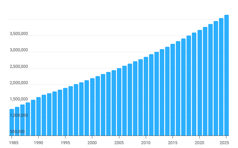
The current metro area population of Lucknow in 2026 is 4,229,000, a 2.32% increase from 2025. The population of Lucknow is increasing at a rate of over 2% every year. This influx has created intense pressure on the the city’s transport infrastructure, making it inadequate to meet the commuters expectations. 
image 1
Rapid Growth in Vehicle Population

Lucknow’s mobility landscape is dominated by a sharp rise in private vehicles. As per VAHAN data, the city has over 3.17 million registered vehicles. Two-wheelers (around 2.16 million) and four-wheelers (about 0.78 million) form the majority, indicating a strong dependence on personal transport. In addition, there are over 107,000 three-wheelers, along with freight vehicles, tractors, ambulances, and other categories.

Rise of E-Rickshaws and Informal Transport

Public transport growth has remained limited, but intermediate public transport, especially e-rickshaws and e-autos, has expanded rapidly. These modes are increasingly filling first- and last-mile connectivity gaps, often operating in areas not covered effectively by formal systems like buses or metro.

Uttar Pradesh Leading in EV Adoption

Uttar Pradesh has the highest number of electric vehicles in India, with over 414,000 EVs, ahead of Delhi and Maharashtra. This growth is reflected in Lucknow as well, where electric three-wheelers and small EVs are becoming a common part of daily commuting.

Infrastructure Growth vs Vehicle Growth

The number of vehicles in Lucknow is increasing at an estimated rate of 10-12% annually, which is faster than the expansion of transport infrastructure. Municipal road length has increased from about 520 km to over 1,545 km, while Public Works Department roads have grown from around 6,200 km in 2021 to 8,700 km in 2024. Despite this, infrastructure development is still lagging behind the pace of motorisation.

Severe Parking Deficit

One of the most critical gaps is parking infrastructure. With more than 3.1 million vehicles in the city, the available parking capacity is less than 3,900 spaces. This mismatch highlights significant challenges in urban planning, congestion management, and land use

Project at a Glance

Lucknow Metro at a Glance

22.88 km
Operational Network
23
Stations
₹383 Cr
FY2025 Revenue
1.30 Lakh
Peak Daily Ridership
Operator
Uttar Pradesh Metro Rail Corporation (UPMRC)
Ownership
50:50 Joint Venture — Government of India & Government of Uttar Pradesh
Operational Line
Red Line (CCS Airport – Munshipulia)
Infrastructure
19 Elevated • 4 Underground Stations
Commercial Operations
Priority Corridor: 5 Sept 2017
Entire Red Line: 8 Mar 2019
Construction Record
Priority Corridor completed in 2 years 9 months
Blue Line (Phase 1B)
11.165 km • 12 Stations
Approved: August 2025
Phase 1B Investment
₹5,801 crore
Target Completion: June 2027

Financial Performance

₹383 Cr
FY2025 Revenue
40%
Fare Revenue
60%
Non-Fare Revenue
0.67 Lakh
Average Daily Ridership (Apr 2025)

Routes of Lucknow Metro

Lucknow Metro Operational Line (Phase 1A)

Line-1: CCS Airport – Munshi Pulia (22.878 km)

  • Length: 22.878 km
  • Type: Elevated (19.438 km with 19 stations) and Underground (4 km with 4 stations)
  • Depot: Transport Nagar
  • Number of Stations: 23
  • Station Names: CCS Airport (underground), Amausi, Transport Nagar, Krishna Nagar, Singar Nagar, Alambagh, Alambagh Bus Station, Mawaiya, Durgapuri, Charbagh Railway Station, Hussain Ganj (underground), Sachivalaya (underground), Hazrat Ganj (underground), K.D. Singh Stadium, Vishwavidyalaya, IT Chauraha, Badshahbagh, Badshah Nagar, Lekhraj Market, Ramsagar Mishra Nagar, Indira Nagar & Munshi Pulia

Lucknow Metro Proposed Line (Phase 1B)

Line-2: Lucknow Railway Station (Charbagh) – Vasant Kunj

  • Length: 11.098 km
  • Status: Approved by India’s Central Government in August 2025
  • Estimated Daily Ridership: 60,000/day
  • Elevated: 4.548 km with 5 stations (GB Marg – Thakurganj)
  • Underground: 6.55 km with 7 stations (Thakurganj – Vasant Kunj)
  • Number of Stations: 12
  • Station Names: Gautam Buddha Marg, Aminabad, Pandeyganj, City Railway Station, Medical College Chauraha, Nawazganj, Thakurganj, Balaganj, Sarfrazganj, Musabagh, Vasant Kunj
  • Note: Phase 1B entered the tendering stage in February 2026, when  AYESA Ingenieria Arquitectura SAU and AYESA India Pvt Ltd entered into a joint venture to carry out the Detailed Design Consultancy work of the project

Lucknow Metro Phase 2 Routes (Proposed)

This phase, designed by DMRC & UPMRCL, includes 3 corridors and involves the construction of 1 new line and 2 line extensions.

  • Extn of Line-1: Munshi Pulia – Jankipuram
  • Extn of Line-2: Charbagh – SGPGI (Sanjay Gandhi Postgraduate Institute of Medical Sciences)
  • New Line-3: IIM Lucknow – Rajajipuram

Built at Record Speed: The Construction Achievement

The Lucknow Metro’s most appreciated achievement is not its technology or its ridership; it is the speed at which it was built. The Priority Corridor from Transport Nagar to Charbagh, spanning 8.5 kilometres, was completed and made operational in 2 years and 9 months from the date of construction commencement in September 2014. This was the fastest metro construction timeline in India at that point, and it earned the Lucknow Metro Rail Corporation the Dun & Bradstreet Infra Award in 2017 in the Metro Rail category.

The engineering challenge of building underground metro infrastructure in Lucknow’s high water table and culturally sensitive urban fabric was critical, and its completion without major disruption was a genuine operational achievement.

UPMRC, the joint venture between the Government of India and the Government of Uttar Pradesh, drew on its institutional learning from this project to subsequently take on the Kanpur Metro and Agra Metro, both of which are now in advanced stages of construction.

Urban Impact: What the Metro Has Changed

Improvement in Travel Time and Connectivity 

The Lucknow Metro’s impact on the city’s urban fabric is measurable across several dimensions. The most immediate is mobility: a commute from the airport to Charbagh railway station that once took 45-60 minutes by road, depending on traffic, can now be completed in under 35 minutes by metro, at a fraction of the cost of a cab or auto-rickshaw. The Red Line connects the city’s two major transport terminals, the airport and the railway station, with its commercial core at Hazratganj and key residential and institutional nodes along the north-south axis.

Surge in Commercial Activity 

The metro has also stimulated commercial activity along its corridor. Station areas, particularly Hazratganj, Charbagh, and Gomti Nagar, have seen increased retail footfall and a rise in commercial property interest. The presence of metro connectivity has become a standard parameter in residential real estate marketing in Lucknow. This transit-oriented development effect, while not yet as pronounced as in Delhi or Bengaluru, is real and growing.

Improved Safety and Mobility for Women

From a gender and safety perspective, the metro has meaningfully expanded mobility options for women in a city where the safety of public transport has historically been a concern. Dedicated women’s coaches, well-lit and CCTV-monitored stations, and predictable timings have made the metro a preferred choice for female commuters, a demographic that private vehicles and informal transport modes frequently fail to serve.

Environmental Benefits and Energy Efficiency: Annually Reducing 6,700 tonnes of CO₂

Lucknow Metro has built a measurable case around energy efficiency and emissions reduction through the use of regenerative braking and solar power. For every 100 units of electricity consumed in operations, around 45 units are recovered and fed back into the system for reuse. This lowers overall energy demand and contributes to a reduction in the system’s carbon footprint.

On a typical day, the metro runs about 190 trips. Each trip requires roughly 250 units of electricity, taking the total daily energy consumption to nearly 47,000 units. Through regenerative braking, about 45% of these, around 20,000 units, are recovered and reused. This translates into a daily reduction of approximately 18.4 tonnes of CO₂ emissions, or about 6,700 tonnes annually. Over six years, this has helped prevent roughly 32,000 tonnes of CO₂ emissions.

In cumulative terms, regenerative braking alone has enabled savings of around 4.3 crore units of electricity over six years. In addition, solar power generation has contributed another 80 lakh units during the same period. These measures together have resulted in annual cost savings of about ₹5 crore, while total carbon emission reductions have crossed 40,000 tonnes.

Only about 40 % of Lucknow Metro’s total income comes from fares; the remaining 60 % is generated through advertising, commercial activities, and other services, offering a model for financial diversification that other cities are studying.

The Revenue Model: A Diversified but Pressured Balance Sheet

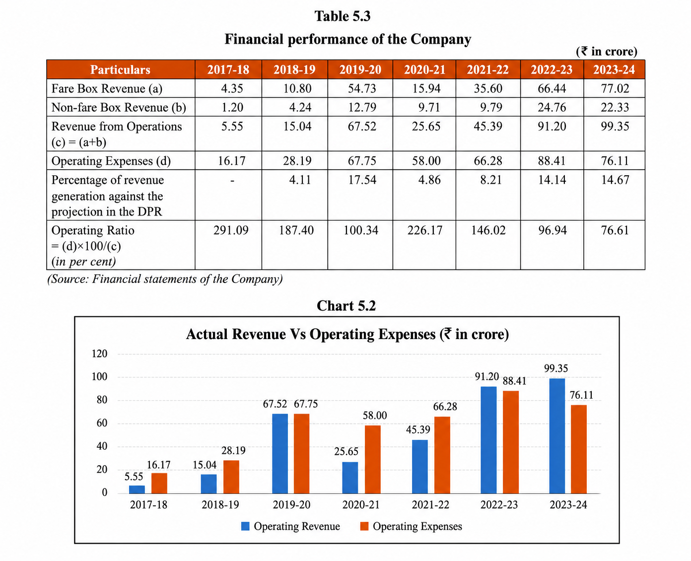
Lucknow Metro’s financial architecture offers one of the more instructive case studies in how Indian metro systems can attempt to build sustainability beyond the fare box. As per a report of First India, approximately 40 % of UPMRC’s total income is derived from passenger fares, while the remaining 60% comes from advertising revenues, commercial space leasing at stations, cultural events, exhibitions, and other non-fare services. UPMRC’s total revenue for FY2025 stood at Rs 383 crore, reflecting a compounded annual growth rate of 23 %, indicating that the revenue base, while not yet sufficient to cover total costs, is growing at a healthy pace.

04194f90 ec6f 4f07 89b1 6d32f92964fd

Source: Comptroller and Auditor General of India

This diversified model is a departure from the fare-centric approach that has left many Indian metro systems financially exposed. By treating stations as commercial assets rather than merely transit nodes, UPMRC has developed revenue streams that are not entirely dependent on passenger volumes. Advertising panels, retail concessions, and cultural programming generate income even on days when ridership is below projections.

However, the broader financial picture is more challenging. UPMRC reported a net loss of Rs 17 billion for FY2023, a figure that reflects the structural reality common to most Indian metro projects: the gap between capital costs, interest burdens on project debt, and operational revenues is large and persistent.

This challenge is not unique to Lucknow. A Parliamentary Standing Committee report in 2022 found that virtually all metro networks in India are running at an operational loss, with fare revenues insufficient to cover even day-to-day operational expenses in many cases. 

Shortcomings of Lucknow Metro: Where the Gaps Remain

Ridership Below Potential

2eba744c c7d2 4475 be0e 90d82bbe6e4a

Source: Comptroller and Auditor General of India

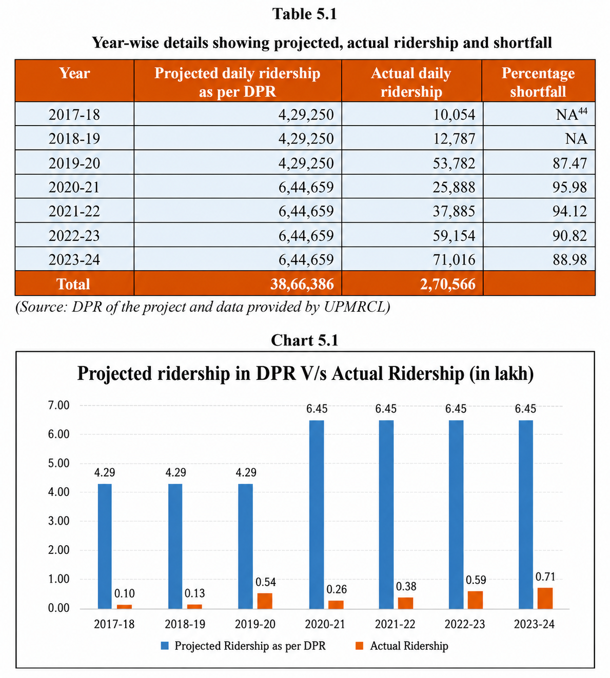
At approximately 78,000-80,000 passengers per day, Lucknow Metro’s average ridership remains below the projections made in its Detailed Project Report and below the threshold typically considered necessary for operational cost recovery. The city’s population of approximately 35 lakh, combined with an urban structure that is less dense and more auto-dependent than metro-friendly cities like Delhi or Mumbai, limits the natural catchment for each station. The Red Line’s north-south orientation serves the city’s main commercial and institutional spine well, but large residential areas to the east and west remain unconnected, limiting the metro’s reach into the bulk of the city’s commuter base.

Last-Mile Connectivity

The single most frequently cited barrier to higher ridership is the absence of reliable last-mile connectivity. Lucknow’s auto-rickshaw and e-rickshaw network around metro stations is informal, unregulated, and inconsistent in availability and pricing. Feeder bus services, while planned, have not been implemented at the scale or reliability required to convert potential metro users into actual ones. Until a commuter can reliably get from their home to a metro station and from a metro station to their destination without uncertainty about cost, availability, or safety, the metro will continue to serve a narrower segment of the population than its infrastructure is capable of serving.

Single Line Dependency

As of now, the Red Line is only operational; the Lucknow Metro functions as a single corridor rather than a network. The value of a metro system increases non-linearly as coverage expands. A two-line network with an interchange is more useful than two single lines in isolation. Until Phase 1B opens and the Blue Line creates a genuine interchange at Charbagh, Lucknow Metro will continue to serve a limited set of origin-destination pairs rather than the city as a whole.

Debt and Financial Overhang

The Rs. 17 billion loss reported in FY2023 reflects the structural financial overhang that comes with a capital-intensive project funded largely through debt. Unless ridership grows substantially or Phase 2 expansion creates the network density needed to drive much higher daily passenger volumes, UPMRC will continue to rely on government equity infusions to remain solvent. This is not an immediate crisis, but it is a long-term sustainability risk that the organisation must address through both revenue growth and cost discipline.

The Sustainability Question: Can Lucknow Metro Build a Viable Future?

Financial sustainability for urban metro systems in India is not achieved through fare revenue alone and it is arguably never achieved through fare revenue alone anywhere in the world. The question for Lucknow Metro is whether it can build the combination of ridership scale, non-fare revenue, transit-oriented development, and network density that makes long-term viability possible.

The Hong Kong MTR model, the global benchmark for financially sustainable metro operations, combines fare revenues with a Rail plus Property development model, where the metro operator develops commercial and residential real estate above and around its stations. The property development revenues fund the gap between operational costs and fare income, creating a self-sustaining financial cycle. UPMRC has not yet adopted this model in a meaningful way; station-adjacent commercial development remains limited relative to the potential that high-footfall metro stations in a growing city like Lucknow represent.

The transit-oriented development policy in Uttar Pradesh is still nascent. While the Lucknow Development Authority has acknowledged the metro’s role in shaping the city’s growth, the regulatory and financial frameworks needed to capture land value uplift along metro corridors through value capture financing, TOD zoning, and developer contribution mechanisms have not been implemented at the scale that would make a material difference to UPMRC’s balance sheet.

Energy efficiency is one area where Lucknow Metro is already delivering tangible financial benefits. The 40 % energy recovery through regenerative braking translates directly into lower power bills, which are among the largest operational cost items for any metro system. 

Ultimately, the sustainability of Lucknow Metro depends on the same thing that determines the sustainability of every mid-size city metro in India: whether the city grows into its metro, or whether the metro is forced to wait indefinitely for the city to catch up. Lucknow is growing, its population is increasing, its economy is expanding, and its real estate market is active. The conditions for a self-reinforcing cycle of metro growth exist. Whether UPMRC can execute Phase 1B on time, build the last-mile connectivity ecosystem that converts potential riders into daily commuters, and develop the commercial assets along its corridors with the discipline of a property developer rather than a public sector utility  these are the variables that will determine whether Lucknow Metro becomes a model for sustainable urban rail in India’s growing state capitals, or remains a well-built but financially stressed infrastructure asset waiting for the city to arrive.

Conclusion

Lucknow Metro is, by almost any measure of construction achievement and operational quality, a success. The metro is built faster than any comparable metro in India’s history, serving a city of 4 million people with reliable, safe, and clean rapid transit.

The harder question is whether success in construction and operations can be translated into financial sustainability and transformative urban impact. Lucknow Metro is serving a fraction of its potential ridership. It is consuming public resources at a scale that requires justification through consistent, growing social and economic returns. Phase 1B, when it opens, will be the most important test of the system’s potential  adding the network density, the interchange connectivity, and the coverage that could meaningfully accelerate ridership growth.

The Lucknow Metro’s story is still being written. The infrastructure is in place. The revenue model, more diversified than most Indian peers, is a foundation to build on. What it needs now is the scale that comes with network expansion, the last-mile ecosystem that converts proximity into usage, and the urban policy environment that allows the metro to become not just a transport service but a driver of the city’s economic and spatial future.

Also Read: Delhi Metro’s Inderlok-Indraprastha Corridor enters construction phase

Kolkata Metro gains momentum with TBM Breakthrough on Purple Line

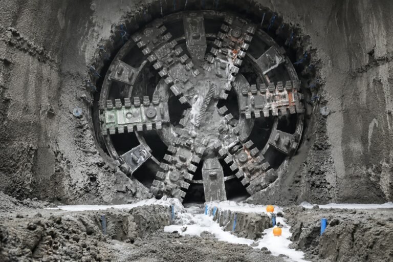
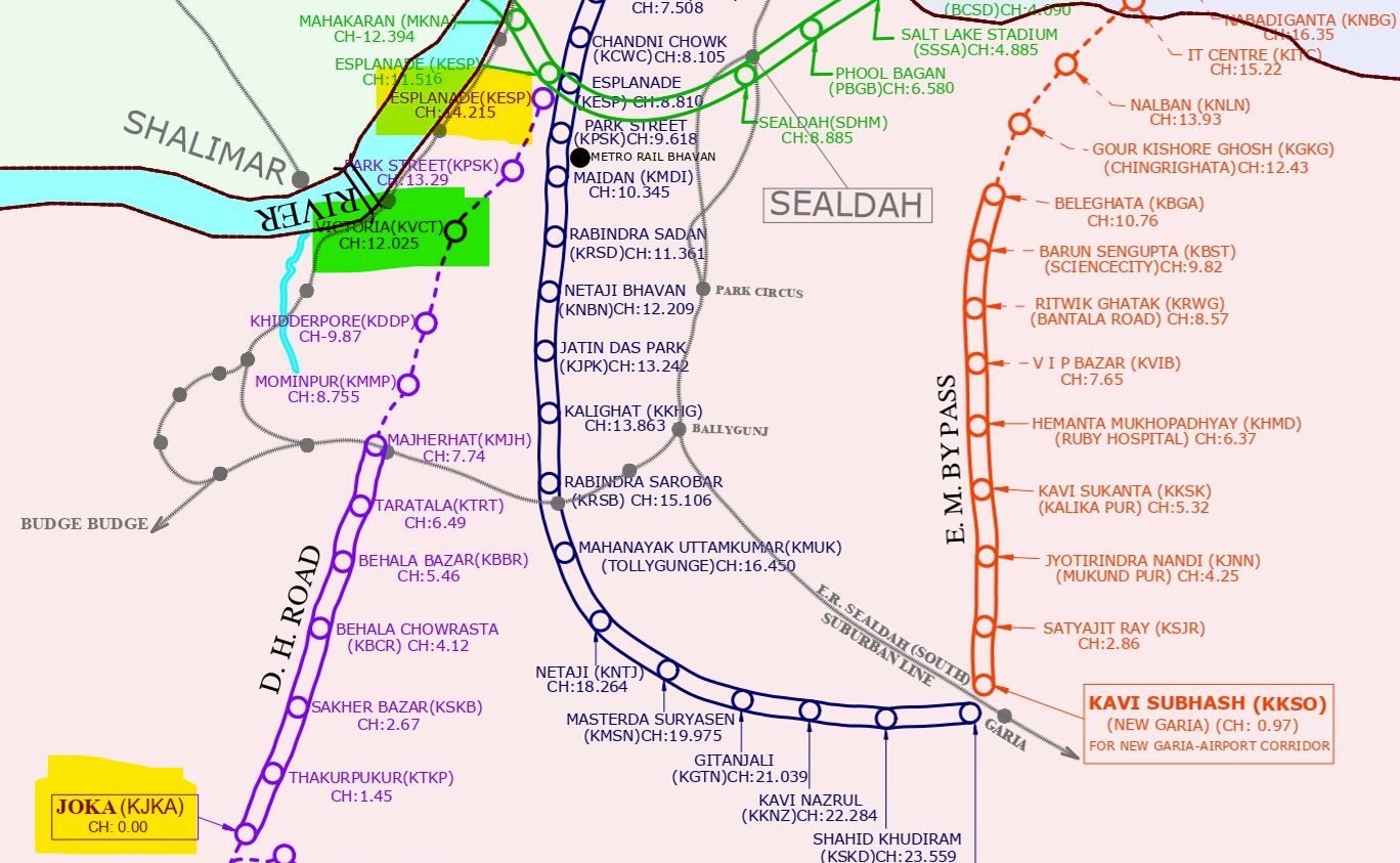
KOLKATA (Metro rail News): Kolkata Metro displayed a major engineering excellence as Tunnel Boarding Machine (TBM) ‘Durga’ achieved breakthrough by constructing an underground tunnel from Kidderpore to Victoria Station on the Purple Line.

On 10 July the TBM Durga reached Victoria Metro Station at 10:30 AM tunneling through a complex underground route. 

The video of the tunnel breakthrough was posted on X (formerly Twitter) by Union Railway Minister Ashwini Vaishnaw:

The 18.84 Km-long Purple Line corridor connects Joka with Esplanade. Currently, the purple line is partially operational with an approximately 7.74 km long fully elevated stretch connecting Joka and Majerhat. The work is under progress in the Majerhat to Esplanade section, while another project was proposed connecting Joka and Diamond Park.

image 4

The construction for the  underground tunnel from Kidderpore to Victoria Station began exactly a year ago on 10th June, 2025. Once completed, the corridor is expected to improve connectivity between south and central Kolkata. 

Mr Prem Sagar Gupta, the General Manager of Metro Railway, Kolkata praised the work of project personnel for ensuring safe, methodical and efficient construction without interrupting the surface traffic mobility.

Also Read: Central Railway commissions indigenous KAVACH safety system along 149-KM route in Solapur division 

Central Railway commissions indigenous KAVACH safety system along 149-KM route in Solapur division 

SOLAPUR (Metro Rail News): The Solapur division of Central Railway has commissioned the indigenous standard KAVACH system for the first time. It has been deployed across the 149.476-kilometre Solapur–Wadi section. Kavach is India’s indigenous Automatic Train Protection (ATP) system that prevents collisions and controls overspeeding through real-time monitoring, enabling faster train operations.

KAVACH uses RFID-based track identification and continuous communication between locomotives and infrastructure.1,234 RFID tags were installed and programmed in Solapur across all route sections to enable precise train location tracking. KAVACH was commissioned at Solapur division on 9 July 2026 by the Signal & Telecommunication (S&T) team. This was the first standard Kavach commissioning in Solapur division.

How KAVACH works: Mechanics of India’s indigenous protection system 

KAVACH continuously tracks train movements using RFID tags on tracks, radio communication between locomotives, stations, and control centers, and by analysing real-time data on signals, speed, and track occupancy. Additionally, it reduces human error. Kavach also has an SOS system that allows immediate emergency communication in case of any danger. Further, it is indigenous and cost-effective too.

This will be a major boost to railway safety and operational excellence in Solapur division. This development highlights the Government of India’s vision for a safer, smarter, and self-reliant railway network under the Atmanirbhar Bharat initiative through modernisation and technological innovation.

Also Read: Delhi Metro’s Inderlok-Indraprastha Corridor enters construction phase

Delhi Metro’s Inderlok-Indraprastha Corridor enters construction phase

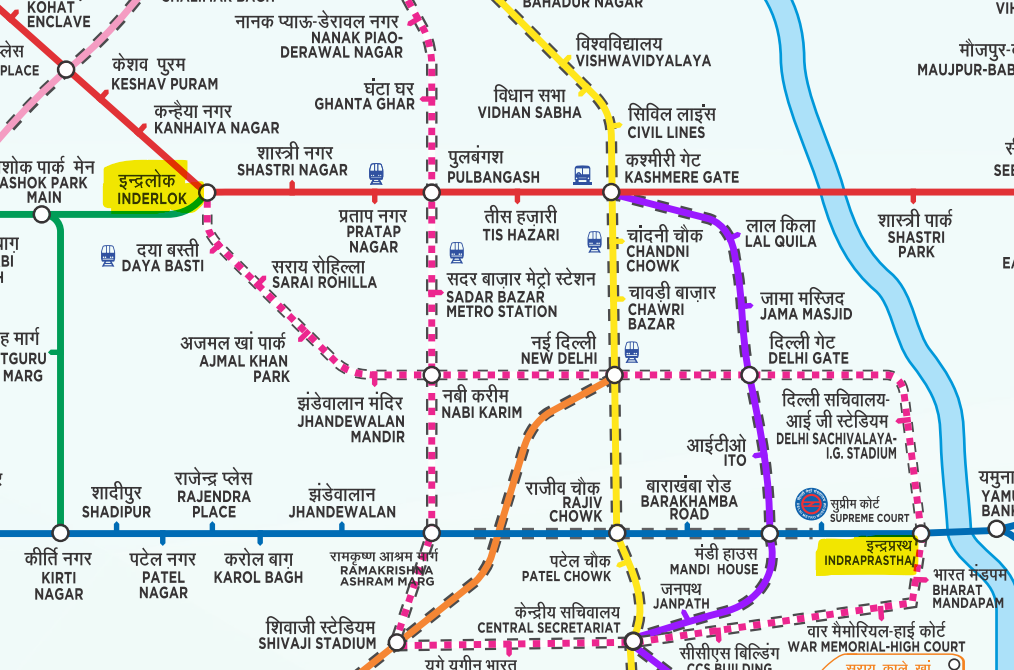
NEW DELHI (Metro Rail News): Delhi Metro began work on the Inderlok-Indraprastha corridor of the Magenta Line extension. The work commenced with the construction of the Diaphragm Wall at the Sarai Rohilla Metro Station site on Thursday (July 10). The Inderlok-Indraprastha corridor will be a 12.377 km long fully underground extension of the Magenta Line (Line 8).

The proposed Sarai Rohilla metro station is a major station located at the center of Delhi improving connectivity with education institutes, markets and other commercial places in the area. Mrs Rekha Gupta, Delhi’s Chief Minister was present at the Sarai Rohilla metro station for the commencement of the work. 

Mapping for Interconnectivity

The corridor will have 10 underground stations. These stations will foster interchange across seven other lines of the Delhi Metro. The following stations are planned in this corridor:

image
  • Inderlok (providing interchange with Red Line and Green Line)
  • Daya Basti
  • Sarai Rohilla
  • Ajmal Khan Park
  • Jhandewalan Mandir
  • Nabi Karim (providing interchange with Magenta Line’s branch line)
  • New Delhi (providing interchange with Yellow Line and Orange Line)
  • Delhi Gate (providing interchange with Violet Line)
  • Delhi Sachivalya I.G. Stadium
  • Indraprastha (providing interchange with Blue Line)

Magenta Line to become Delhi Metro’s Longest Line

Magenta Line is projected to become the longest line in the Delhi Metro with a length of approximately 89 km after the implementation of the proposed extension. Moreover, it will feature 21 interchange stations, the highest number of interchange stations across the network. Currently, it is lagging behind the Pink Line (71.55 km) with 49.12 km length. The construction work on Magenta Line’s Central Vistas corridor and Janakpuri West-R.K Ashram Marg is in progress.

Also Read: Work began at the Saket G Block station, Golden Line expected to be open soon

Ghaziabad-Jewar RRTS Corridor moves into DPR stage

NEW DELHI (Metro Rail News): Noida International Airport will soon be connected to Ghaziabad, as the Ghaziabad-Jewar RRTS corridor has entered the Detailed Project Report stage. With an operating speed of 180 kmph, this Namo Bharat corridor is expected to cut travel time from Ghaziabad to Jewar to approximately 40-50 minutes. NCRTC Managing Director Shalabh Goel confirmed that DPR’s are being prepared for the Ghaziabad-Jewar and Noida-Faridabad-Gurgaon corridors.

Proposed Ghaziabad-Jewar RRTS corridor stations: 

  • Ghaziabad
  • Ghaziabad South
  • Greater Noida West-Sector IV
  • Greater Noida West-Sector II
  • Knowledge Park V
  • Surajpur
  • Pari Chowk
  • Ecotech VI
  • Dankaur
  • YEIDA North-Sector 18
  • YEIDA Central-Sector 21 
  • Jewar Airport

The project is planned to meet rising passenger demands and improve connectivity between Delhi NCR cities and Noida airport, linking important residential areas and commercial hubs. This line will have 12 stations and two depots, one at the northern end and one at the southern end.

Shalabh Goel also mentioned that the government is expected to approve two major RRTS corridors soon, the Delhi–Panipat–Karnal and Delhi–SNB–Alwar RRTS Corridors. He added that preparatory work such as geotechnical studies, utility mapping, and shifting or modifying infrastructure like Extra High Tension (EHT) lines and water pipelines is already underway for these projects. These steps will be taken once all necessary approvals are obtained, preventing delays and allowing the projects to proceed smoothly. He also noted that other states are looking into planning their own RRTS corridors to keep up with rapid urban growth and rising transportation needs.

Also Read: Patna to get RRTS links in all four directions; NCRTC to prepare DPR

Union MoS (Railways) Ravneet Singh Inspects Jalandhar Cantt Station Prior to PM Modi’s Visit

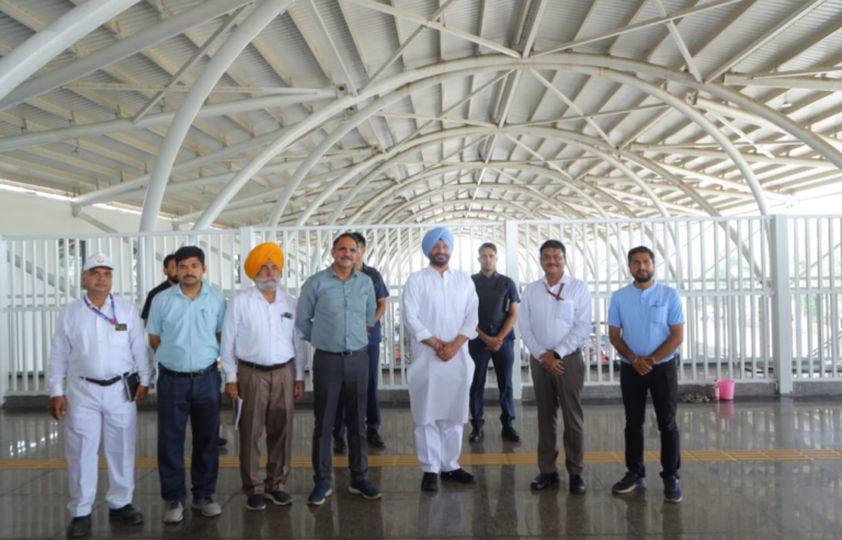
JALANDHAR (Metro Rail News): Union MoS for Railways & FPI  Shri Ravneet Singh Bittu visited the  Jalandhar cantt  Railway Station under the Ferozepur Division on Wednesday, July 8, 2026, to review preparations for Prime Minister Narendra Modi’s upcoming visit on July 17.

During his inspection, Minister Shri Bittu spoke extensively about the project’s significance and its upcoming inauguration. He expressed his gratitude to Prime Minister Modi and Railway Minister Ashwini Vaishnaw for the modernization initiative, describing it as a landmark development for Punjab.

The revamped Jalandhar Cantt Railway station boasts an expansive steel-concourse of 8,720 sq.m.,topped with a 40-meter-wide roof that extends 200 meters across the platforms, offering travelers a spacious, weather protected experenience. Enhancing its splendor is a 36-meter-wide air concourse that spans 1,770 sq.m., effortlessly linking both sides of the city and enhancing accessibility for countless passengers each. In addition to officially dedicating the ₹125-crore Jalandhar Cantt station upgrade to the public, the Prime Minister is expected to use the venue to virtually inaugurate approximately 75 other completed Amrit Bharat Stations across the country.

Addressing the media after the review session, Minister Shri Bittu highlighted that the 110-year-old station has been transformed into a world-class facility under the Amrit Bharat Station Scheme. He emphasized that the revamped station stands as a major architectural landmark for Punjab, celebrating the region’s cultural ethos while providing highly efficient, congestion-free transit for the more than 7,500 passengers who use the facility daily.

According to reports from the Ministry of Railways, construction has entered its final phase. The inspection primarily focused on rectifying minor initial deficiencies and ensuring the highest standards of safety, security, and last-mile connectivity ahead of the Prime Minister’s high-profile visit.

Also Read: Patna to get RRTS links in all four directions; NCRTC to prepare DPR

Patna to get RRTS links in all four directions; NCRTC to prepare DPR

PATNA (Metro Rail News): Patna, the capital of Bihar, will get a semi-high speed rail network or Regional Rapid Transit System (RRTS) connectivity with the neighbouring cities of Muzaffarpur, Begusarai, Arrah and Gaya. Bihar’s Chief Minister Samrat Choudhary approved ₹31.59 Crore for the Alternative Analysis Report (AAR) and Detailed Project Report (DPR) preparation of the State’s RRTS project in a meeting held on Wednesday (July 8). 

National Capital Region Transport Corporation (NCRTC) has been nominated for preparing the  DPR and the AAR for the construction of these RRTS corridors. It will assess the feasibility of the project and prepare a comprehensive report for future approvals.

The Chief Minister called this decision as “an important step towards the development of a fast, safe and modern public transport network, strengthening regional connectivity and boosting the urban development and economic growth in the state.”

The Namo Bharat Corridor in the Delhi NCR will serve as a model for this project. India’s first semi-high speed rail corridor with a speed up to 180 kmph, the Delhi-Meerut RRTS project has significantly reduced the travel time between these cities. This corridor is expected to reduce Delhi’s congestion and improve the regional connectivity between Delhi and its nearby cities.

Significance of the Route

Patna has emerged as Bihar’s most developed city in all the socio-economic aspects. In addition to serving as the administrative capital, it is also the busiest city in the state attracting people from nearby cities for work, education, industries and commercial activities.

The proposed RRTS will boost the regional connectivity in Bihar by providing semi high-speed rail network in the following corridors:

  • Patna-Muzaffarpur
  • Patna-Begusarai
  • Patna-Arrah
  • Patna-Gaya

These four proposed corridors connect Patna in all directions with Muzaffarpur in North, Begusarai in East, Arrah in West and Gaya in South. The four corridors are projected to significantly reduce the travel time between Patna and its neighbouring districts. 

Also Read: Patna Metro to extend till Malahipakri; inauguration on 2nd July